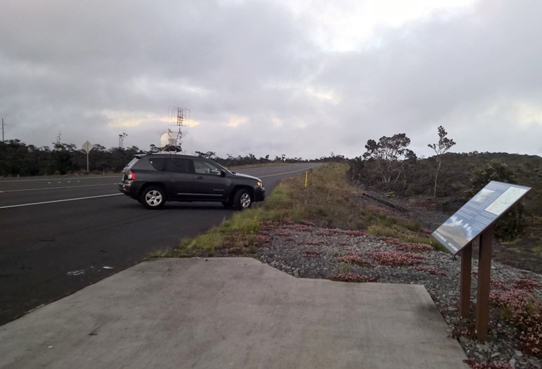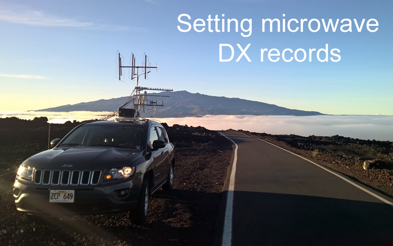
N6NB's suitcase portable station on a rental car is shown at 8,000 feet elevation on Mauna Loa. Mauna Kea, Hawaii's other 13,000-foot volcanic mountain, is in the background. The tropospheric duct is in the cloud layer. N6NB's "tool box" rover stations might be better known for making microwave contacts across a few grid squares than for setting world distance records, but on June 18, 2015, new world records on 2304 and 3456 MHz were set by KH6/N6NB and W6IT. N6NB was operating portable in a rental car on the big island of Hawaii while W6IT was operating N6NB's fixed station with rover-type components in Panorama Heights, near Orange, California. Those microwave contacts spanned a distance of 4,024 km--almost 2,500 miles, breaking records that had stood for more than 20 years. A year later, N6NB and W6IT broke another distance record, this one on 902 MHz. N6NB again operated portable in a rental car on the big island of Hawaii, but W6IT also operated portable this time, taking one of N6NB's rover stations to a site 75 miles inland in the San Bernardino Mountains. Their contact covered 4,095 km, breaking another record that stood for more than 20 years. What follows is an account of how this happened from N6NB. A narrated PowerPoint presentation about these DX records was prepared for the 2016 Central States VHF Conference in case I didn't get back from Hawaii in time to speak in person. It's a large file (including video clips) that can be downloaded here. W6IT's companion PowerPoint presentation about building a complete 10-band microwave station is here. A week before the record QSOs in 2015, the Hepburn forecast of tropospheric propagation suggested that a duct might form across the Pacific in a few days. I bought an airline ticket and packed a station for all bands from 144 MHz through 10 GHz in two large suitcases plus a roll-aboard and a backpack (total weight: 150 pounds). When I got to Kona on the big island of Hawaii, I rented a small SUV (a Jeep Compass), drove across the island to Hilo and built a station in/on the rented car. Fortunately, the car had tie-downs on the roof, although there was no roof rack in the usual sense--just decorative trim. I built a rotating roof platform with parts from Home Depot. When the duct formed on Tuesday (June 16), I drove all over the slopes of the Mauna Loa volcano while listening to my own 222.030 MHz beacon in Orange County, Calif. I was looking for good sites, but it was a thrill just to hear the beacon from 2,500 miles away. By Thursday, the duct seemed to be at its best. Greg, W6IT, activated my station In Panorama Heights and we worked Thursday night on six bands, including 2304 and 3456 MHz, both for new world DX records. I heard Greg well on two more bands, 902 and 5.7 GHz, but local QRN in Orange County prevented him from hearing me on those two bands. The record-setting QSOs occurred at 0257z (2304) and 0300z (3456) on June 19 (Thursday afternoon, June 18, Hawaiian time). W6IT was fixed in grid square DM13cs, while KH6/N6NB was portable in BK29hq. The center-to-center distance between the two is 4,024 km. According to the database of records maintained until recently by W5LUA, the old record was 3,982 km., set by KH6HME and N6CA on 14 July 1994 (2304, on CW) and 28 July 1991 (3456, on SSB). The W6IT - KH6/N6NB contact was the first-ever SSB contact between Hawaii and the mainland on 2304. It was about double the distance of the previous longest SSB QSO on that band. World tropospheric DX records as of June 30, 2016, are shown below. A video of the record-setting 2304 QSO between KH6/N6NB and W6IT, as recorded in N6NB's rental car, is online at www.n6nb.com/2304rcrd.mp4 Note: this large file may take several minutes to load. The entire W6IT - KH6/N6NB run through the bands was amazingly easy. After working on 144, 222 and 432, we went to 1296 and quickly exchanged reports. It was a short but solid QSO. I told Greg to flip the bandswitch to 2.3. I heard him there instantly--and had the presence of mind to grab my smartphone and make a video of this little piece of history as we completed the record-breaking two-way contact on 2304. Then I asked Greg to switch to 3.4. I heard him on 3.4 instantly, too. The first thing he said was, "oh, you're even louder than on 2.3." That was before he even gave his grid. After another short contact, we went to 5.7. W6IT was Q5 once again, but he couldn't hear me over his S4 or S5 noise level (probably from nearby Part 15 wi-fi devices). We did go on to 10 GHz, but we couldn't hear each other there. We planned to try again on 10 GHz later, but the tropo deteriorated and there was no "later" for us on that band. This was all done with two relatively modest stations. You can see what they look like fairly well in the photos above and below. On the California end, Greg was using a fixed tower, but the equipment and antenna setup on top was almost identical to what I've displayed on my tower trailer at various VHF conferences: short loopers, a 2' dish, etc. The home station tower has a black box at the top. It's not actually a tool box, but it's similar to my "tool box" rover stations. It houses DB6NT transverters and amplifiers. The measured power output is about 10 watts on 2.3 GHz, 5 watts on 3.4, 8 watts on 5.7 and almost 10 watts on 10 GHz. On the KH6 end, I was also using DB6NT transverters and amplifiers housed in a black box. The measured power output is: 16 watts on 2.3 GHz, 19 watts on 3.4, 15 watts on 5.7 and 28 watts on 10 GHz. That system made it to KH6 as checked luggage, but there were three broken right-angle SMA connectors when it got there. I had enough spares--but just barely. Hawaii's two 13,000-foot volcanic peaks are both very cold at the top even in summer. I've never operated at the top of either one, but I've also never operated in more rugged terrain than the slopes of Mauna Loa. The mountainsides are bleak and forbidding, but the tropo duct--when you can get into the middle of it--is magical. Antennas small enough to fit inside a suitcase fully assembled are capable of sending and receiving signals across an ocean within the duct. * * * The 2016 contact that broke the 902 MHz record occurred on June 30 at 2333z. During what turned out to be a very brief trans-Pacific opening, I tried several sites on the slopes of Mauna Loa and concluded that the best site was the same one I used a year earlier, The higher elevations were in warm, clear weather and the clouds were burning off even there. Meanwhile, Greg took one of the rover stations to an overlook at 6,200 feet elevation on Rim of the World Highway near Running Springs, CA (DM14kf), 75 miles from the coastline but line of sight to it. Choosing to try to set a DX record from a site so high in elevation and so far inland was admittedly risky. The duct is usually very low on the California end, often only a few hundred feet above sea level. Stations at higher elevations often have far more difficulty working Hawaii than those at low elevations looking into the duct along the coastline. However, as the duct breaks up over land, it's sometimes possible to put a signal into the end of it from a high elevation far inland. We were lucky--again. With N6HC operating the Panorama Heights station for liaison (thanks, Arnie), I was ablde to work Greg quickly on 144, 222 and 432 MHz. He was getting into the duct from afar. We went to 902 and immediately worked each other with SSB signals running S2 or S3 on peaks, but with deep fading. We continued to work on 902 as we tried higher frequencies--to no avail. It turned out that 902 must have been near the maximum usable frequency over this partly-overland path on this particular day. Our record of 4,095 km breaks a record of 4,064 km set in 1994 by KH6HME and N6XQ. There are photos of this venture below the photos of the 2015 contacts. We were using 60-watt Down East Microwave transverters and short loop Yagis on both ends of the 902 contact. While some ducts linger for several days (one in July, 2014 lasted eight days), the 2016 duct was good for only a few hours. Greg's signals and even N6HC's at Panorama Heights faded into the noise level around 0400z on July 1. Fortunately, I had worked a number of other stations during the short opening. There was not going to be another chance during that opening. Greg put the Panorama Heights station on the air the next day, and signals rose out of the noise level long enough for us to work, but only briefly and only on 144, 222 and 432. No other stations were readable the next day. A video clip of the record-setting 902 MHz QSO, as recorded in N6NB's rental car, is online at www.n6nb.com/902clip.wmv * * * It has been 60 years since John Chambers, W6NLZ, and Ralph "Tommy" Thomas, KH6UK, made their historic first California-to-Hawaii contact on two meters on July 8, 1957. They worked on 222 MHz two years later. At that point the U.S. Navy used its pre-existing Project Tradewinds as a way to study the duct that made these astonishing amateur contacts possible. The Navy concluded that "elevated ducts" are found at tropical latitudes in several places around the world. In the case of the duct that forms between the west coast and Hawaii, the duct is at a low elevation at the mainland end. The best signals into the duct usually come from stations a few hundred feet above sea level with an unobstructed view out to the Pacific. On the Hawaiian end, the duct may be 5,000 to 8,000 feet above sea level. The elevation can vary considerably with local weather conditions. Sometimes Hawaiian stations at sea level can get into the duct fairly well, and often the famous KH6HME beacons get into the duct reasonably well even when the beacon site at 8,200 feet elevation is above the cloud tops that mark the top of the duct. After the remarkable QSOs between W6NLZ and KH6UK, there was a 13 year hiatus. There were no more reported VHF amateur radio contacts between California and Hawaii via tropo until 1973, when a duct formed that was impossible to miss. Many California stations were able to key up high-elevation Hawaiian repeaters. Hundreds of VHF contacts were made across the Pacific. As a footnote to this, four young hams from Orange County, Calif. not only worked Hawaii from home but also went on a tropo duct DXpedition to Point Sal near Santa Maria, California. The four, K6YNB (now N6NB), WB6ASR (now W6IT), WB6RAL (now W6MT) and WB6RIV (now AA6DD) made many, many additional Hawaiian contacts from a fog-enshrouded bluff about 500 feet above the Pacific at Point Sal. There are photos of that expedition so many years ago at the bottom of this page. After the 1973 opening, trans-Pacific VHF contacts became commonplace. I wrote an article for the September, 1976 issue of QST about a big opening earlier that year. Soon two Hawaiians, KH6HME and KH6IAA, began driving up Mauna Loa to put big signals into California. KH6HME went on to become legendary when he set up beacons in a corrugated metal building owned by a public television station. Paul Lieb's name was synonymous with working Hawaii for more than 30 years. Paul was on one end of every world DX record from two meters to 5.7 GHz by the time of his passing in 2012. KH6HME's call lives on as a memorial club call and the KH6HME beacons continue to run 24/7, alerting west coast DXers to Hawaiian openings. I would like to thank Greg, W6IT, for his able operating on the California end of the 2015 and 2016 record-breaking QSOs and at Point Sal 42 years earlier.
-Wayne Overbeck, N6NB
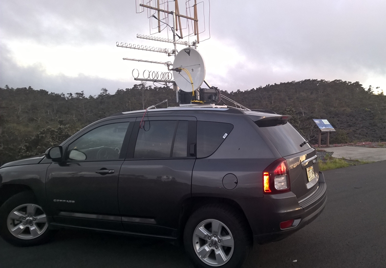
This site on Daniel Inouye Highway at an elevation of 5,260 feet is where the record-breaking microwave contacts occurred both in 2015 and in 2016. The photo below shows the view, such as it is, looking toward California through the tropo duct. The views are much nicer above the duct--but the signals are NOT nicer up there.
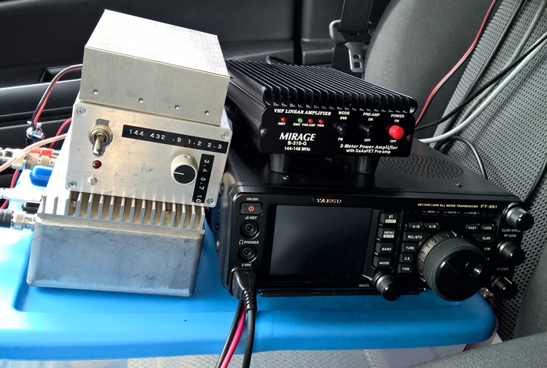
This is N6NB's entire operating position
in the Hawaiian rental car. There is a Downeast Microwave 222 transverter
(bottom left), a homemade bandswitch unit and 24-volt power source for
a Rubidium reference oscillator (top left), a Mirage B-310G amplifier for
two meters, and a Yaesu FT-991 transceiver, all atop a plastic storage
box. The sole purpose of the plastic box is to elevate the gear for
easier access. The bandswitch unit controls the microwave transverters
and amplifiers that are housed in a weatherproof box on the car's roof.
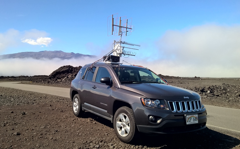
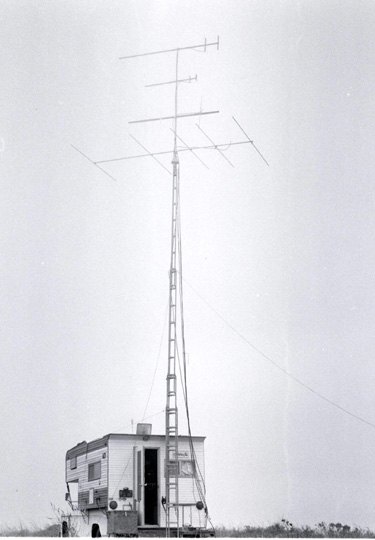
This photo was taken along the Mauna Loa Observatory Road at 7,100 feet, low enough to be at the top of the duct on this particular day in 2015. A day earlier the cloud tops were above the KH6HME beacon site at 8,200 feet.
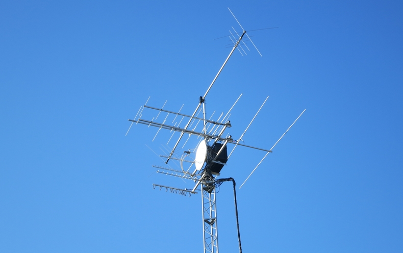
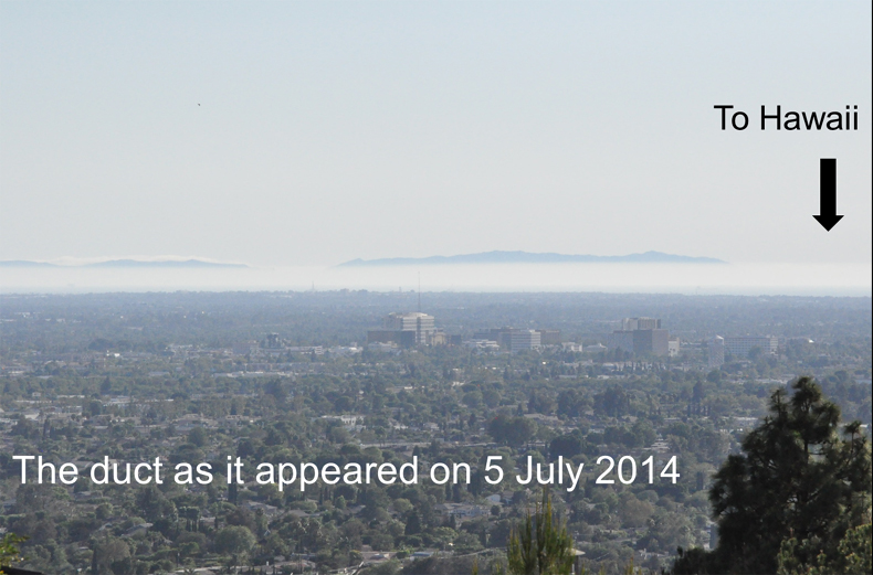
This photo, taken by W6IT, shows the tower at Panorama Heights. It has a clear view into the Pacific tropo duct from an elevation about 500 feet above the surrounding terrain in Orange County, Calif. The antennas and microwave hardware are nearly identical to what has been used in N6NB's rovers. The photo below shows the view these antennas see when pointed southwest during a tropo duct. The mountains that rise above the duct are on Catalina Island, about 30 miles off the California coast from this vantage point. The path to Hawaii passes over the Santa Catalina Channel between the mainland and the island.
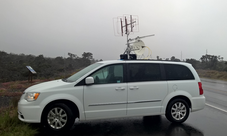
Using a rented minivan on June 30, 2016, KH6/N6NB set up at the same turnout as in 2015 and worked W6IT for a new DX record on 902 MHz.
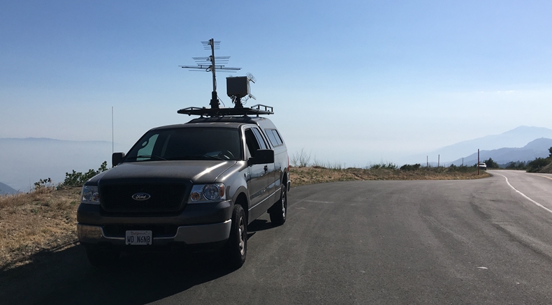
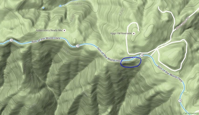
W6IT took N6NB's highest-power rover station to a turnout along Rim of the World Highway (DM14kf) near Running Springs, CA for the record-breaking 902 MHz contact in 2016. This site is 6,200 feet above sea level and 75 miles inland--but with a clear shot toward the ocean between two mountain ranges.
This terrain map shows the extreme drop-off in the direction of Hawaii from W6IT's site in the San Bernardino Mountains. The heading to Hawaii is about 259 degrees with the map oriented so that north is up.
|